
Written by Ceezaer Drone Services
Official publication of ceezaer.com — Veteran-Owned · FAA Part 107 · Round Rock, TX
Official publication of ceezaer.com — Veteran-Owned · FAA Part 107 · Round Rock, TX
Central Texas averages three to five damaging hail events per year, and a single storm can drop stones larger than 2 inches across an entire metro. Manually spotting hail bruises on a roof is slow, subjective, and dangerous. AI-assisted drone imagery now flags impact marks, granule loss, and fractured mats at a scale and consistency no ladder inspection can match.
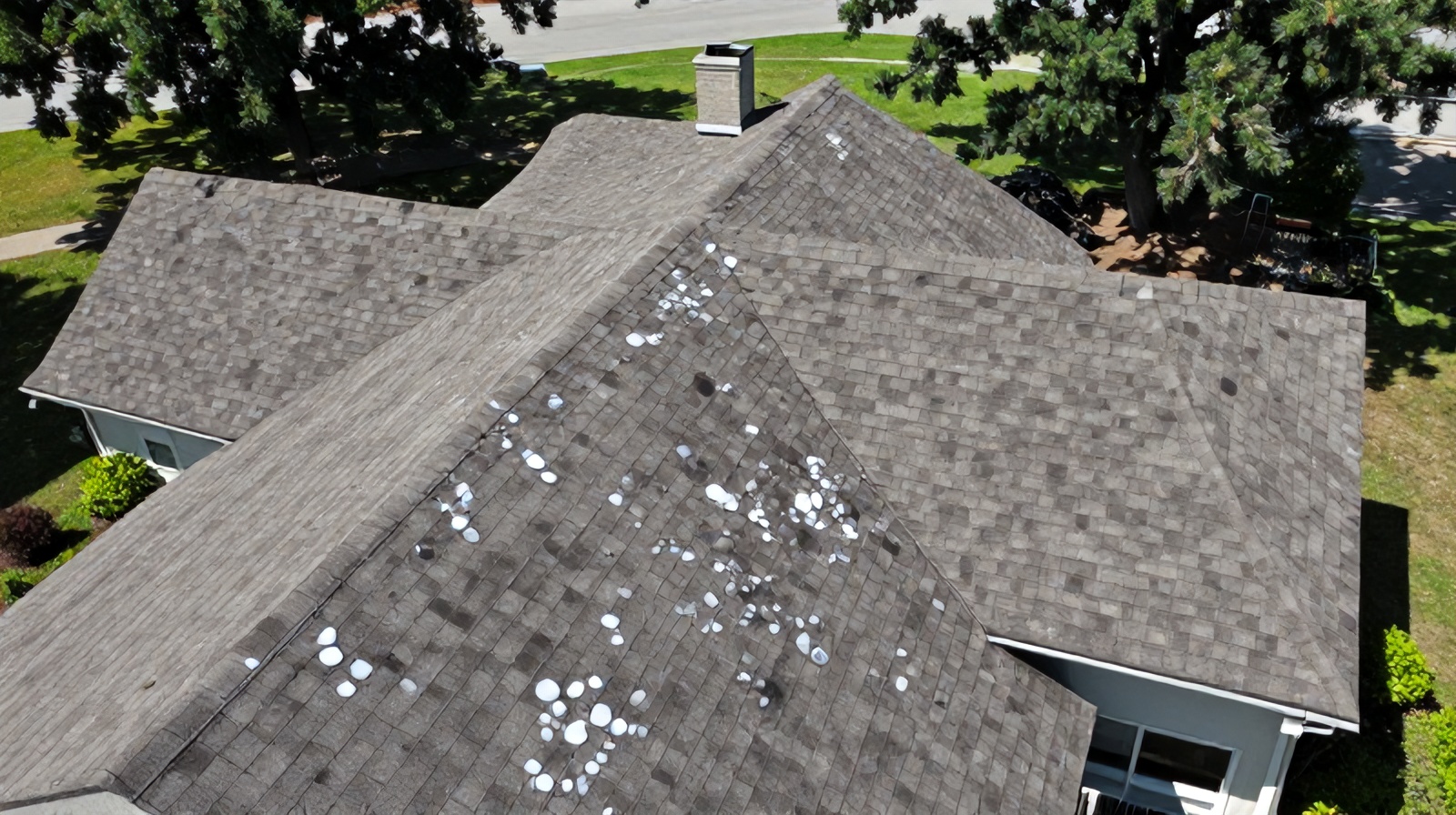
Hail damage rarely looks like a hole. It looks like subtle bruising, and human eyes miss it constantly.
When hail strikes an asphalt shingle, it fractures the fiberglass mat beneath the surface and knocks loose the protective granules. The result is a soft, circular bruise roughly the diameter of the stone that hit it. On a fresh roof these marks are dark where granules are missing; on a weathered roof they blend into normal wear. A single 30-square residential roof in Round Rock can carry hundreds of these impacts, and an adjuster walking the roof has minutes, not hours, to find and mark them.
The stakes are financial. Insurers require documented, countable evidence of storm damage to approve a replacement. Miss a slope and a legitimate claim gets underpaid. Over-mark it and the claim gets flagged for review. Traditional inspection also puts a person on a steep, storm-loosened surface, which is exactly where fall injuries happen. This is the gap that AI hail damage detection in drone imagery is built to close.
Texas makes the problem worse than most states. The I-35 corridor sits in a zone where warm Gulf moisture collides with dry continental air, producing supercells that drop large hail spring through early summer. A property manager overseeing dozens of buildings after one storm cannot climb every roof in the window insurers expect. Aerial capture plus automated review changes that math.
The pipeline is capture, alignment, and computer-vision classification, with a human reviewer at the end.
The process starts with a structured drone flight rather than a few snapshots. A Part 107 pilot flies a grid or orbit pattern that captures every slope at consistent overlap, usually 75 to 85 percent, from an altitude of roughly 60 to 120 feet. That overlap lets photogrammetry software stitch the images into a single high-resolution orthomosaic and, crucially, gives the AI multiple looks at each shingle from slightly different angles so a shadow is not mistaken for a bruise.
The detection itself relies on convolutional neural networks trained on tens of thousands of labeled hail-strike examples. The model learns the visual signature of an impact: a roughly circular zone of granule loss, a darker exposed mat, and often a faint spatter mark on adjacent surfaces. Because hail falls with directional bias in wind-driven storms, models also weigh the density and orientation of marks across a slope, which helps separate true hail from foot traffic, mechanical damage, or blistering.
The network labels each candidate mark as hail, mechanical, blistering, or normal wear, then scores its confidence. This separates storm damage from the everyday defects that inflate false claims.
Detected strikes are plotted per slope and per test square. Adjusters count hits in a 10-by-10-foot square, and the AI reproduces that standard automatically across the whole roof.
Wind-driven hail concentrates on storm-facing slopes. Consistent directional patterning strengthens the case that damage came from a datable weather event, not age.
When a prior baseline flight exists, the system compares imagery over time to prove new damage occurred after a specific storm date.
No credible model runs fully unsupervised on a claim. The AI does the exhaustive first pass, flagging every candidate and building the count, then a trained analyst validates the flags and removes false positives. That human-in-the-loop step is what makes the output defensible to an insurer.
A repeatable five-step sequence turns raw aerial images into a document an adjuster can act on.
The pilot flies a mapped grid at fixed overlap and altitude, capturing nadir and oblique images so every slope, valley, and penetration is documented at high resolution, typically better than a quarter inch per pixel.
Photogrammetry software aligns hundreds of frames into a georeferenced, measurable map of the roof. This gives the AI a clean, distortion-corrected surface to analyze and lets anyone measure slope area later.
The trained model scans the imagery, marks every candidate impact, classifies it, and produces a hit count per test square and per slope, along with confidence scores.
An analyst reviews flagged detections against raw imagery, discards false positives such as lichen or foot scuffs, and confirms the counts that will support the claim.
The final package includes annotated imagery, per-slope damage density, measured roof area, and a summary that maps directly to the format adjusters expect. Ceezaer delivers this within 48 hours of the flight.
The technology is powerful, but it is not a substitute for judgment or a functional inspection where a physical touch is required.
On clean asphalt-shingle roofs with good lighting, well-trained hail detection models report recall above 90 percent, meaning they flag the large majority of genuine impacts. Consistency is the real advantage: the AI applies the same criteria to slope one and slope forty, at hour one and hour eight, with no fatigue. It counts hits objectively, which reduces the disputes that arise when two human inspectors disagree.
The limits are real and worth stating plainly. Detection quality drops on wood shake, tile, and standing-seam metal, where the visual signature of hail differs from the asphalt examples most models are trained on. Low sun angles cast long shadows that mimic bruising, and midday glare can wash out granule contrast, so flight timing matters. Wet roofs, heavy debris, and dense tree cover all degrade results. And some damage, such as a soft bruise that has not yet lost granules, is genuinely felt more than seen and may require a hands-on check.
Used correctly, AI does not replace the inspector or the adjuster. It gives them a complete, countable, safety-first first pass so their expertise goes toward decisions rather than climbing and counting.
The value shows up in speed, safety, and stronger claims after the storms that hit this region every spring.
After a major hail event, thousands of Austin-metro properties file claims at once, and adjuster availability tightens for weeks. A property manager with a portfolio of retail centers or apartment communities cannot wait that long to know which roofs need action. A drone can document a large roof in a fraction of the time a manual inspection takes, and the AI report arrives while the storm date is still fresh, which matters because insurers scrutinize the gap between the event and the claim.
The documentation itself is also stronger. An annotated orthomosaic with measured slope areas and per-square hit counts is harder to dispute than a handful of phone photos. When a claim is challenged, the raw imagery is preserved and reviewable, so the evidence does not depend on one person's memory of the roof. For contractors and roofers, the same dataset doubles as an accurate takeoff for the replacement bid. Ceezaer, a veteran-owned and $1.5M-insured operation based in Round Rock, built its roof reporting around exactly this pairing of aerial capture and AI-flagged output for the Central Texas market.
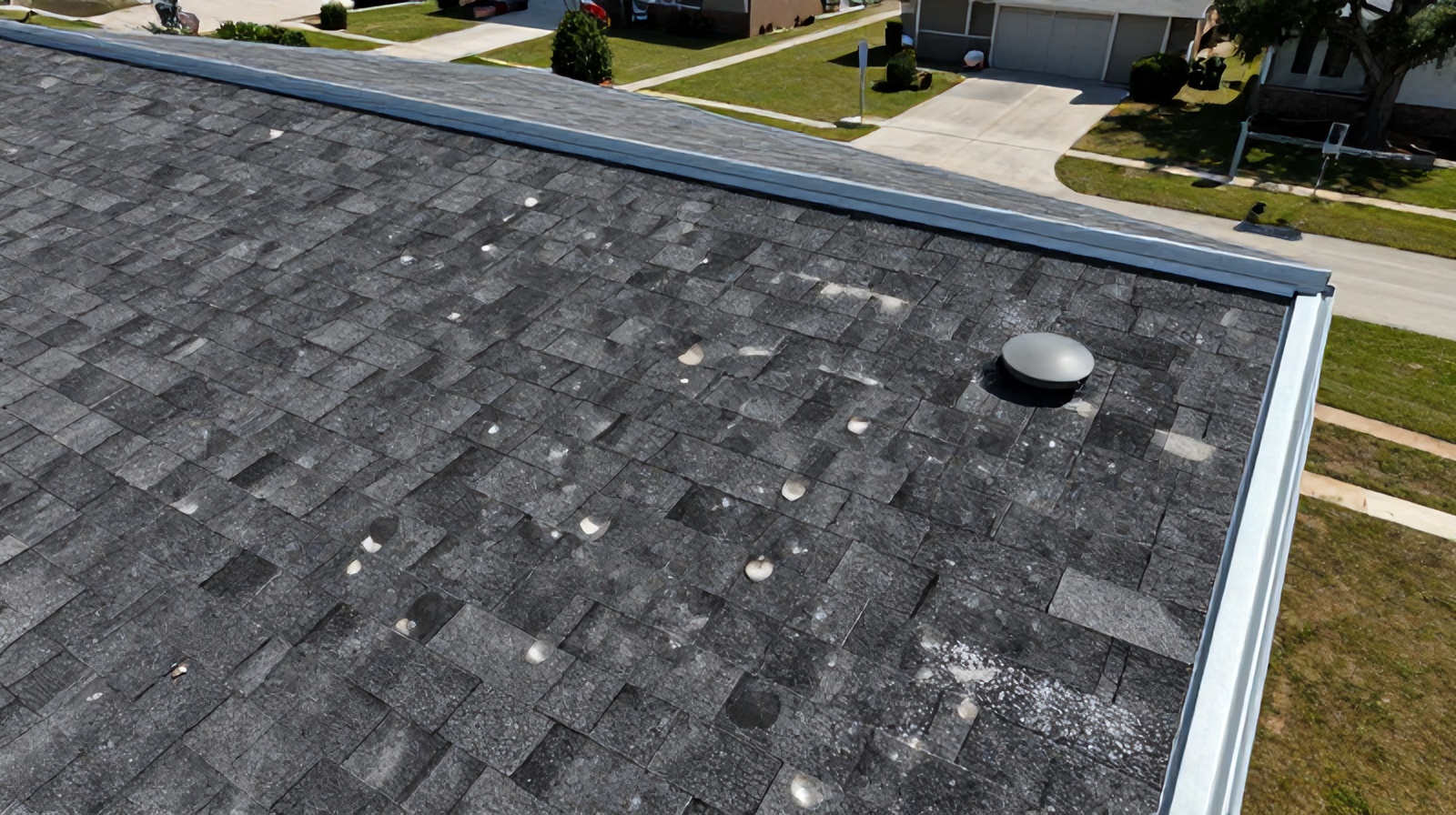
© 2026 Ceezaer™ Drone Services. This article was written and published by Ceezaer (ceezaer.com). All rights reserved — reproduction or republication without written permission is prohibited. Original URL: https://ceezaer.com/blog/ai-detect-roof-hail-damage-drone-imagery
Pairs hail-impact detection with thermal imaging to find moisture that visual scans miss.
Shows how aerial evidence supports the claims process hail reports feed into.
Compares the speed and safety tradeoffs behind aerial hail assessments.