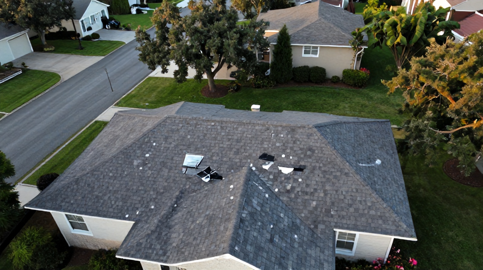
Traditional property damage claims take weeks to assess and are routinely contested. Drone inspections deliver documented, georeferenced damage evidence in hours — accelerating settlement timelines, reducing fraud exposure, and protecting both carriers and policyholders with objective aerial data.
The traditional property damage claims process has well-known inefficiencies that drone technology is now directly addressing.
A conventional storm damage claim triggers a sequence of delays: the policyholder files the claim, the carrier dispatches an adjuster from a regional office (often backlogged after a major storm event), the adjuster schedules an appointment and physically visits the property, and inspects the roof by climbing it or using binoculars from the ground. The inspection produces a set of photos, a narrative description of conditions, and a damage estimate based on what the adjuster could see. This process takes 7–21 days under normal claim volume conditions — and 4–8 weeks after a major hail or wind event when adjuster capacity is overwhelmed by simultaneous claims.
Drone inspection compresses this timeline dramatically. A licensed drone operator can inspect 8–12 properties per day — compared to 2–4 for a traditional adjuster doing manual roof inspections. The drone captures a complete, georeferenced, high-resolution record of every square foot of the affected roof surface in 15–30 minutes per property. The evidence package is available for adjuster review within hours rather than days. When the adjuster reviews the drone report, they are looking at documented evidence of every impactful hail strike, dent, granule loss pattern, and membrane breach — not a selected sample of what they could safely reach from a ladder.
Claim filed → adjuster assigned (1–5 business days) → site visit scheduled (3–10 days) → manual roof inspection, 2–4 hours → photos and notes compiled → estimate prepared (2–5 days) → settlement offer communicated → potential dispute and reinspection (adds 2–6 weeks). Total timeline: 3–8 weeks under normal conditions; 6–16 weeks after major storm events.
Claim filed → drone deployed same or next business day → complete aerial documentation in 15–30 minutes → georeferenced damage report with AI analysis delivered within 24 hours → adjuster reviews documented evidence remotely → settlement offer based on objective documentation (1–2 days) → dispute rate dramatically reduced by photographic evidence. Total timeline: 3–7 business days under normal conditions; 2–3 weeks after major storm events.
A professional drone inspection for insurance purposes is not simply a collection of aerial photographs. Each deliverable element serves a specific evidentiary function.
Hail impact on roofing materials produces characteristic patterns visible in high-resolution aerial imagery: circular granule displacement on asphalt shingles, dents and breaches on metal panels, cratering on TPO and EPDM membranes. A 20MP camera at 20 meters altitude captures individual hail strikes with 2–5 mm resolution — sufficient to classify impact diameter and density across the entire roof surface. The drone's systematic grid flight produces an orthomosaic that documents hit density per square foot, enabling accurate damage scope quantification rather than extrapolation from a sample area.
Wind damage to roofing and building envelope produces damage patterns that are difficult to assess from ground level but clearly visible from above: lifted or missing shingle tabs, damaged ridge cap sections, displaced metal flashing, torn membrane sections, and displaced fascia or gutters. The overhead perspective also captures structural damage to rooftop HVAC units, skylights, and roof-mounted equipment that ground inspection typically misses or underestimates. GPS coordinates allow the adjuster to identify the exact roof location of each damage instance without ambiguity.
One of the most contentious issues in property damage claims is distinguishing storm-caused damage from pre-existing conditions or wear. AI analysis of drone imagery compares the distribution, pattern, and morphology of observed damage against storm event parameters (hail size, storm track, impact angle) and typical aging patterns for the specific roofing material. Damage consistent with the storm event is clearly differentiated from wear-related deterioration, giving adjusters an objective basis for coverage determination that is far more defensible than a subjective manual assessment.
Accurate roof measurement is essential for replacing estimates. Manual measurement from the ground or from partial roof access produces errors of 5–15% for complex roof geometries. Drone orthomosaic measurement of roof planes — hip ridges, valley lines, rake edges, and total square footage — is accurate to ±1–2%. This measurement accuracy directly affects replacement cost calculations: a 10% measurement error on a 5,000 sq ft commercial roof creates a $15,000–$40,000 error in the replacement estimate at current Texas roofing labor and material costs.
For properties enrolled in a pre-event documentation program — particularly commercial properties, HOA portfolios, and managed rental properties — a baseline drone inspection creates a documented pre-storm condition record. When a claim is filed after a subsequent storm event, the comparison between pre-event baseline and post-event inspection is irrefutable evidence of what damage was caused by the specific storm vs. what existed previously. This eliminates the most common basis for claim disputes and dramatically accelerates settlement.
Property insurance fraud — including inflated claims, staged damage, and claims for pre-existing conditions — costs the US insurance industry $34 billion annually. Texas is consistently among the top states for property claim fraud volume.
Drone inspection addresses multiple fraud vectors simultaneously:
Texas is the most hail-impacted state in the US. Understanding the local claims environment explains why drone inspection capacity is not a luxury — it is operational necessity for Austin-area carriers and adjusters.
The Austin–San Antonio corridor sits in "Hail Alley" — the geographic region with the highest hail event frequency in North America. Central Texas averages 3–6 significant hail events per year (2" or larger hailstones), with individual events affecting 50,000–500,000 properties in a single storm track. The April 2021 Austin hail event generated over $850 million in insured losses from a single multi-county storm system. At traditional adjuster capacity (2–4 inspections/day), processing 50,000 simultaneous claims requires 12,500–25,000 adjuster-days — physically impossible without supplemental drone capacity.
The Austin commercial real estate construction boom has created enormous new commercial property insurance exposure concentrated in Round Rock, Cedar Park, and the Domain area. Large flat-roof commercial buildings are particularly vulnerable to hail damage — their horizontal surfaces present full exposure to impacting hailstones, and TPO and EPDM membrane systems are more susceptible to hail impact at equivalent stone sizes than steep-slope residential shingles. Commercial property drone inspection — covering 20,000–200,000 sq ft per flight — is the only economically feasible approach to post-event commercial portfolio assessment.
The window for accurate storm damage documentation is limited. Within 30–90 days of a storm event, temporary repairs obscure original damage patterns, UV degradation begins at fresh impact sites, and rooftop foot traffic from multiple inspectors alters the pattern of granule displacement used to assess impact density. Early drone documentation — ideally within 5–10 business days of the event — captures the fullest and most accurate evidence record before post-event conditions degrade the evidentiary value of the inspection.
Aerial inspection for property claims has moved from innovation to industry standard in the major carrier market over the past five years.
State Farm, Allstate, Farmers, and USAA have all deployed drone inspection programs at significant scale, using both internal drone operators and third-party inspection services for claim volume management. The adoption drivers are consistent across carriers: lower per-inspection cost, faster cycle time, and reduced litigation from objective documentation. Swiss Re and Munich Re, whose reinsurance exposure to US hail events is enormous, have both published research supporting drone inspection as a loss control best practice that reduces reinsurance claims volatility.
For independent insurance adjusters and regional carriers operating in Texas, third-party drone inspection services like Ceezaer provide the aerial inspection capability of a large carrier program without the overhead of maintaining an internal drone operations team. A third-party inspection partnership provides: FAA-certified operators, maintained insurance and equipment, processed deliverables within 24 hours, and scalable capacity during peak post-storm claim periods when internal staff is overwhelmed.
In the majority of residential and standard commercial property claims, drone inspection documentation provides sufficient evidence for settlement without requiring an additional physical inspection. Some carriers have established drone-first inspection protocols where physical adjuster inspection is triggered only when drone data is inconclusive (e.g., snow cover, dense vegetation, complex architectural features that require interior access). For claims with interior damage components (ceilings, walls, contents), drone inspection documents the exterior cause but an interior inspection remains necessary for the interior scope.
All major US property insurance carriers accept professionally produced drone inspection reports as claim evidence. Most carriers who actively use drone inspection specify deliverable requirements (georeferenced orthomosaic, GPS-tagged individual images, measurement report) that Ceezaer's standard deliverable package satisfies. For carriers who do not have an established drone inspection protocol, a professionally documented drone report is admissible evidence under standard insurance industry evidence guidelines and is treated equivalently to a comparable-quality manual inspection report.
Ceezaer maintains surge capacity protocols for post-event claim response. After a significant hail or wind event affecting the Austin metro, we can deploy within 24–48 hours of clearing weather (drone operations require calm wind, no rain) and can process 8–15 property inspections per day per operator. For carrier or adjuster clients with significant claim volume, pre-event response agreements establish priority access to inspection capacity and accelerated turnaround during surge periods. Contact info@ceezaer.com to discuss a preferred partner arrangement.
For a standard residential property (2,500–5,000 sq ft roof), a comprehensive drone insurance inspection including flight, processing, georeferenced orthomosaic, individual damage documentation, and measurement report is $350–$600. For commercial properties, pricing scales with roof area: $500–$1,200 for buildings up to 30,000 sq ft, $1,000–$2,500 for larger commercial properties. Volume pricing for carrier or adjuster programs managing multiple claims is available and typically reduces per-inspection costs by 20–40% for commitments of 20+ inspections per month.
Limited roof access — steep slopes, fragile materials, occupied commercial buildings where roof access creates disruption, multi-story structures without safe ladder access — is one of the primary reasons drone inspection is adopted as an alternative to traditional inspection. Drone inspection does not require physical roof access at any point. The drone captures the complete roof surface at sufficient resolution for damage assessment from air. This eliminates both the physical risk to the inspector and the scheduling friction of arranging safe physical access to complex properties.
How thermal drone inspection finds hidden moisture damage that visual inspection and claims adjusters miss.
Our full aerial inspection offerings for insurance carriers, adjusters, and property owners in Austin.
How AI classifies and quantifies property damage from drone imagery — the technology behind the report.